top of page

Garmin

ABOUT GARMIN

Garmin is a global company with offices in the U.S., Europe and Asia. At these facilities, Garmin carry out various stages of product development, from initial concept to mass production of shelf-ready units. Garmin are able to maintain a high level of quality while also responding more quickly to the ever-changing marketplace.
Products include Multibeam Sonar, Conventional/Chirp Sounders, Side and Down View, Autopilots, Communications, Daylight Viewable Monitors to name a few. 
Fremantle Marine are a service level GARMIN dealer, we offer the following GARMIN products:

garmin_LGO_104.jpg

Garmin MSC10 Satellite Compass

GARMINs new Satellite Compass can connect to any NMEA2000 network and provide accurate Position, Heading, Attitude and Heave data. Connect to your autopilot for amazing heading accuracy, also be used for heave compensation on compatible echo-sounders!

The multi-band GNSS (L1 and L5 GPS) and multi-constellation (GPS, Galileo1, GLONASS and BeiDou1) receiver delivers precise positioning up to 1Mtr.

MSC10.jpg

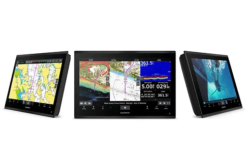
GPSMAP 8400xsv SERIES

GARMINs latest Multi Function offering is a completely redesigned combo unit with amazing features: IPS 1920x1080 display, HDMI input and output allowing you to use the 84xx series as a HD monitor, or output to any HDMI display.

gpsmap-8412.jpg

GPSMAP 952xs & 1222xsv Touch Series

  • 1 kW single-channel CHIRP sonar provides crystal-clear images with remarkable target separation and definition

  • ClearVü and SideVü scanning sonars deliver nearly photographic images of what is below, around and to the sides of your boat (SideVü not available with 952xs)

  • Fully network capable to build your marine system; network sharing allows you to share data among all compatible units connected to the network

  • Compatible with optional BlueChart® g2 Vision® HD charts and LakeVü HD Ultra maps for Auto Guidance¹ and more

  • Supports Panoptix™ all-seeing sonar

garmin1222 touch.jpg

GPSMAP 1022/1222xsv (Keyed Version)

10/12 inch Chartplotter/Sonar Combo is All-in-1 Solution with with keypad interface and multifunction control knob.
Features inlude a high-sensitivity internal 10 Hz GPS and GLONASS receiver, built-in Garmin CHIRP sonar, CHIRP ClearVü and CHIRP SideVü scanning sonar and Panoptix™ support (transducers sold separately).
Fully network capable for Garmin Marine Network and NMEA 2000® plus NMEA 0183 support.
Experience an advanced all-in-1 solution with our 10/12inch GPSMAP 1x22xsv keyed combo. It also has built-in support for Panoptix all-seeing sonar and premium Garmin sonar modules (transducers sold separately). Features a large, bright screen coupled with a quick and easy-to-use keypad interface with user-programmable keys and a multifunction control knob.

1222.jpg

ECHOMAP ULTRA SERIES

  • Keyed-assist touchscreen combo includes all-in-one transducer for CHIRP traditional and Ultra High-Definition ClearVü and SideVü scanning sonars

  • Built-in support for the full line of Panoptix™ sonars and the Panoptix LiveScope™ scanning sonar system, including Panoptix LiveScope LVS12 sonar

  • Preloaded with BlueChart® g2 coastal charts with Auto Guidance1 technology

  • Share sonar, waypoints and routes with other ECHOMAP Ultra 10” and 12” units as well as ECHOMAP Plus 7” and 9” units

  • Built-in Quickdraw Contours mapping software instantly creates personalized fishing maps on-screen with 1’ contours as you fish

  • Built-in Wi-Fi® connectivity pairs with the free ActiveCaptain® app

  • NMEA 2000® connectivity and support for heading sensors, autopilots, digital switching, FUSION-Link™ audio system and more

Available in a 10inch and a 12inch version. Comes complete with transducer.​

echomap-ultra-family.jpg

ECHOMAP PLUS 95SV SERIES

  • Bright, sunlight-readable 9” keyed-assist touchscreen combo

  • Includes transducer for Garmin high wide CHIRP traditional sonar plus CHIRP ClearVü™ and CHIRP SideVü™ scanning sonars and compatible with Panoptix™ all-seeing sonar (sold separately)

  • Preloaded Australia and New Zealand maps

  • Built-in Garmin Quickdraw™ Contours mapping software instantly creates personalised fishing maps on-screen with 1’ contours as you fish

  • Use built-in Wi-Fi® to pair with the free ActiveCaptain™ app for access to OneChart™, smart notifications¹, Garmin Quickdraw™ Community data and more

echomap plus 9.jpg

84xx MULTIFUNCTION DISPLAY (MFD)

  • Premium full HD display with pinch-to-zoom touchscreen control has highest resolution on the marine market

  • Configure the full system to provide 1-touch setting access for docking, cruising, fishing, anchoring and more

  • Beautiful glass helm look with ability to install multiple displays either flush or flat mounted edge-to-edge

  • High-performance processor delivers our fastest map drawing ever and enhanced video processing

  • Provides a superior user experience across your entire network for radar, sonar and multimedia

Large-format multifunction display features a full HD screen with touch control. Sunlight-readable, anti-glare display is exceptionally easy to view and also includes auto-dimming feature for use in low light or at night. New maximum glass design enables you to experience a beautifully powerful, completely networked helm at your fingertips. In-plane switching (IPS) LCD display — an industry first for this class — provides consistent, accurate colors from all viewing angles. It also provides standard USB touch output for use as a touchscreen monitor for Windows® and Mac® operating systems. Install multiple displays with the industry’s lowest flush-mount profile or flat mount them edge-to-edge to create a sleek glass helm look. Quick, 1-touch access to the information you need makes boating easier.​

Available in 17-inch, 22-inch and 24-inch.

garmin-gpsmap-8424-24-multifunction-disp

GARMIN TRANSDUCERS

Garmin offer a wide range of transducers from 250w single frequency, all the way up to 3KW Broadband multi-element designs.

Fremantle Marine Electronics can match almost any transducer from any manufacturer to work with a GARMIN MFD, GPSMAP, or sonar module. 

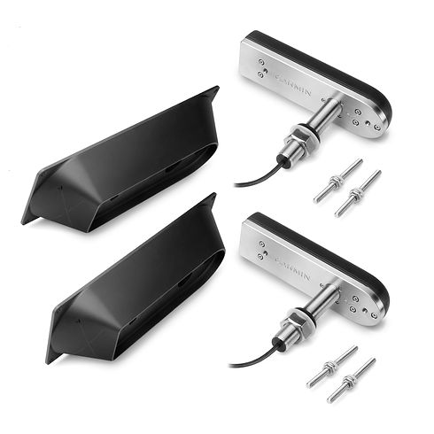
Some popular frequency/power combination are a single channel 28Khz 3KW transducer - it can be used from 5Mtr depths all the way out to 2000Mtr with very high clarity, or GARMIN's own GT51-M (80-160Khz / 600W) complete with sidescan and clear-vu offers a very versatile transducer that works reliably to approximately 200Mtr depths.

For wide seafloor coverage there is the PANOPTIX range of transducers which work to approximately 90Mtr depths. 

For 'live' viewing of the life and seafloor Garmin's latest release 'LIVESCOPE' cannot be missed. This unique transducer offers an almost video quality view of fish, seafloor and structure, up to depths of 40Mtrs.

GT51 Side VU pair.jpg

AUTOPILOTS

GARMIN autopilots are built to work for your vessel! With a solid-state 9-axis Attitude Heading Reference System (AHRS), or optional Satellite Compass the GHP Reactor™ autopilot series holds your course even when your boat is pitching and rolling in rough water. Offers flexible installation options and requires a minimum amount of commissioning and calibration. The result is a more comfortable ride, while heading error, course deviation and rudder movement are minimised.

Options range from a SOLENOID drive version, hydraulic pump version without display (to suit a vessel which already has a Garmin network display), integrated variable speed pumps all the way up to steer-by-wire systems for Yamaha Helm Master, VOLVO-Penta, or Viking VIPER.

Whatever your steering system is, there is a GARMIN autopilot that can can steer your vessel.

garmin-ghp-reactor-hydraulic-corepack.jp

VHF & AIS

Garmin offers communications and Automatic Identification Systems (AIS) designed to enhance convenience and safety for mariners worldwide. All include Digital Selective Calling (DSC), a global protocol that uses channel 70 to transmit and receive digital messages. VHF radios equipped with DSC can send and receive digital emergency messages, private calls and general calls and let you call attention to VHF calls by using stored Maritime Mobile Service Identity (MMSI) numbers. DSC significantly improves the chances of rapid rescue.

Garmin_VHF110_VHF210_AIS-702x336.jpg

inReach Satellite Technology

With inReach satellite technology from Garmin and a satellite subscription, you can stay in touch globally. You can send and receive messages, navigate your route, track and share your journey and, if necessary, trigger an SOS to get emergency help from a 24/7 global monitoring center via the 100% global Iridium® satellite network.
Includes the inReach SE+, inReach Explorer+ and the inReach Mini.

Garmin-inReach-explorer-GPS-satellite-ph
bottom of page